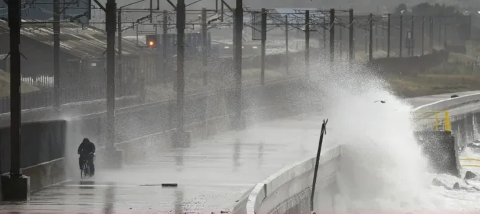
Yellow weather warnings issued as powerful storm system threatens severe UK disruption
Britain is bracing for another spell of violent weather this week as forecasters warn of torrential rain, fierce winds and possible power cuts from a rapidly deepening Atlantic low-pressure system.
The Met Office has issued yellow weather warnings for both wind and rain across large parts of southern and eastern England, as well as west Wales and the south-west, from Thursday morning into late evening. The system, while not yet officially named, has the potential to become the next significant European storm, possibly dubbed Storm Bram or Storm Benjamin, depending on which country’s weather agency names it first.
Heavy rain is expected to sweep across southern England from late Wednesday night, spreading north-east through Thursday and lingering until nightfall. The Met Office has warned that some areas could see 30–50mm of rainfall — up to two inches — with localised flooding and transport disruption likely. The heaviest downpours are forecast across Devon, Cornwall, and eastern England, where some spots could exceed those totals.
Forecasters are also warning of dangerous winds as the system intensifies. Gusts of 45–55mph (70–90km/h) are expected widely, with coastal areas seeing potential gusts up to 65mph (105km/h) — and possibly higher in isolated bursts. For a short period on Thursday morning and into the afternoon, wind speeds could reach 75mph (120km/h), strong enough to fell trees, damage power lines, and disrupt travel by land, air, and sea.
Embed from Getty Images
“While there’s still some uncertainty around the storm’s exact intensity,” the Met Office said, “the potential for damaging gusts and heavy rainfall is significant enough to warrant early warnings.”
The yellow warning for rain is valid from midnight to 9pm on Thursday, while wind warnings cover west Wales and south-west England from 4am to 6pm, and eastern England from 9am to midnight.
The severe weather is being driven by a deepening low-pressure system tracking across southern England. It’s on course to bring storm-force winds to parts of continental Europe as well, where the impact could be greater than in the UK.
If the storm is named, the decision will depend on which national meteorological agency deems the impacts most severe. Under Europe’s storm-naming collaboration, countries are grouped into regional partnerships. The UK, Ireland, and the Netherlands form the western group, while France, Belgium, Luxembourg, Spain, and Portugal make up the south-western group.
If the storm’s strongest effects hit northern France or Belgium, Météo France or Belgium’s Royal Meteorological Institute could name it Storm Benjamin, the second on their list this season. However, if the Netherlands determines that its impacts will be greater there, it could be named Storm Bram, taken from the western European list — which also includes the UK.
Meteorologists stress that these discussions are coordinated to avoid confusion. “It might sound complicated, but all national agencies collaborate closely,” said Simon King, the BBC’s lead weather presenter. “A consistent name will be chosen once its severity and track become clear.”
The Met Office currently believes conditions in the UK are just below the threshold for an official storm naming. Nonetheless, forecasters urge the public to stay vigilant, as the situation could change rapidly if the system deepens further than expected.
Residents in affected regions are being advised to secure outdoor items, avoid coastal areas, and allow extra time for travel. Local authorities have also warned that heavy rain could make driving hazardous, with standing water and debris likely on roads.
While this potential storm may not rival last year’s severe weather events, forecasters say it’s another reminder that autumn’s storm season is fully under way. As one meteorologist put it, “We’re entering the time of year when the Atlantic really wakes up — and this could just be the start
